
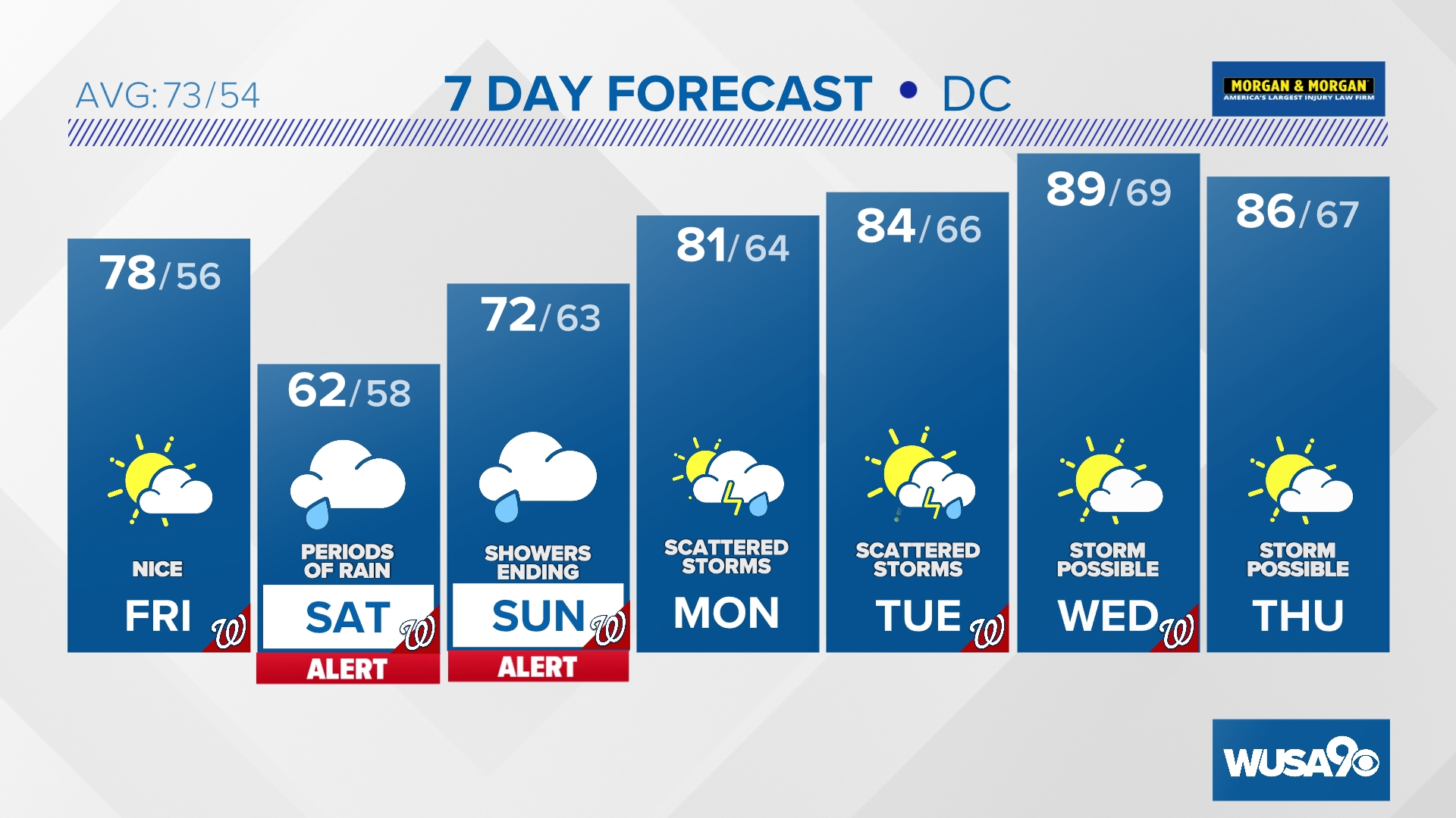
WASHINGTON — We've issued a Weather Watch Alert for periods of rain and showers Saturday and Sunday.
Quick Forecast:
Friday: Warm with increasing p.m. clouds. High: 78.
Friday Night: Mostly cloudy and mild with some showers late. Low: 56.
Saturday: Much cooler with periods of light rain and drizzle. High: 62.
Waking up to nice sunshine Friday morning before clouds gradually thicken up throughout the afternoon and especially the evening. We won't be anywhere near record territory Friday, but temperatures will still be above average in the upper 70s and low 80s.
Showers will start to push east of I-81 later Friday night and lead us into a wet and chilly weekend.
It won't be a total washout, rather a weekend with cloudy skies and off and on periods of rain and drizzle. Weekend baseball and soccer will more than likely still be played, but there's a risk of postponement and even cancellation. It will still be ok to attend the Landon Azalea Festival just bring an umbrella and a light jacket.
Highs will be noticeably cooler, in the 50s and 60s Saturday. Sunday will be a few degrees warmer in the upper 60s and low 70s. Saturday night and Sunday morning looks like the wettest part of the weekend with moderate showers at times with an isolated storm.
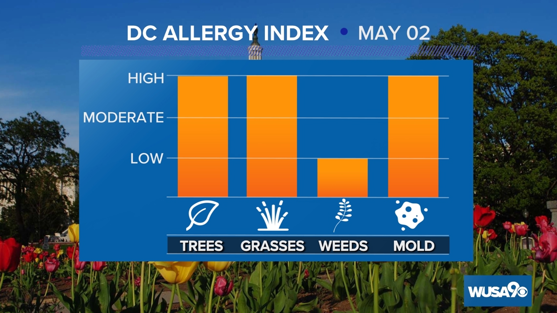
Here is the latest pollen report:

Detailed Forecast:
Friday: Warm with increasing p.m. clouds. Highs: 76 - 81. Winds: E 10 - 15.
Friday Night: Mostly cloudy and mild with some showers late. Lows: 50s. Winds: E 10.
Saturday: Much cooler with periods of light rain and drizzle. Highs: 57 - 62. Winds: E 10.
Sunday will start off damp with rain and showers in the morning. The second half of the day looks mainly cloudy but mainly dry. We may luck out with a few breaks of sunshine in the late afternoon and early evening.
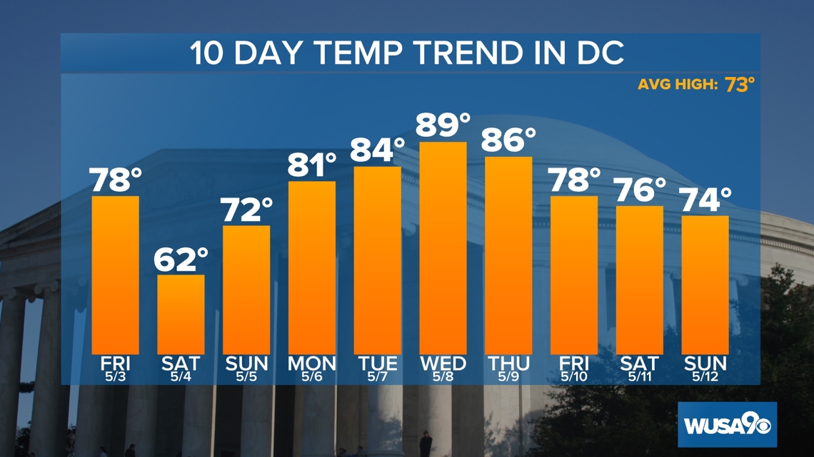
Temperatures will be above average once again next week with high temperatures in the low to mid 80s Monday and Tuesday before climbing back near 90 by Wednesday.
Each day features the chance for a few afternoon showers and thunderstorms with Monday and Tuesday looking the most likely for wet weather.
Extended Forecast:
Sunday: Mostly cloudy and not quite as chilly with rain and showers ending. Highs: 67 - 72
Monday: Partly cloudy and warmer with scattered p.m. showers and storms. Highs: 77 - 82.
Tuesday: Mostly cloudy with spotty showers and thunderstorms. Highs: 80 - 85.
Wednesday: Partly sunny and hot with an isolated shower or thunderstorm. Highs: 85 - 90.
Thursday: Partly sunny and warm with a stray storm possible. Highs: 82 - 87.


MORE WAYS TO GET WUSA9
DOWNLOAD THE WUSA9 APP
Apple App Store: WUSA9 News on Apple
Google Play Store: WUSA9 News on Android
HOW TO ADD THE FREE WUSA9+ APP TO YOUR STREAMING DEVICE
ROKU: add the channel from the ROKU store or by searching for WUSA9.
For both Apple TV and Fire TV, search for "WUSA9" to find the free app to add to your account. Another option for Fire TV is to have the app delivered directly to your Fire TV through Amazon.